The MPG mapping project began in October of 2011. A database of 35,000 records was established using data from Mississippi Entomological Museum, two fascicles from the Moths of North America series, and a list contributed by Nolie Schneider of 800+ species she has photographed in her yard in suburban Ottawa, Canada. Additional data from many sources (listed below) have been added to the database. Of about 1,042,198 records processed thus far approximately 500,657 passed through a filtering process and now reside in the database. The distribution of these data is shown in the summary presented below.
Distribution maps now appear at the top of all MPG species pages for butterflies and moths. For some species we do not yet have data to display on the map. In other cases the data are not yet complete enough to adequately describe the range of the species. Collectors and photographers can substantially improve mapping coverage by submitting lists of species they have encountered. See details below.
Database Holdings as of 09-Nov-2013
|
| State/Province | Records | Species |
| | | |
| Alberta | 15,018 | 2,036 |
| Alaska | 1,239 | 310 |
| British Columbia | 11,822 | 2,041 |
| Greenland | 2 | 2 |
| Labrador | 321 | 225 |
| Manitoba | 3,078 | 1,489 |
| New Brunswick | 6,709 | 1,284 |
| Newfoundland | 1,036 | 570 |
| Nova Scotia | 1,936 | 1,026 |
| Northwest Territories | 699 | 364 |
| Nunavut | 177 | 85 |
| Ontario | 15,493 | 2,481 |
| Prince Edward Island | 398 | 316 |
| Quebec | 8,315 | 2,205 |
| Saskatchewan | 2,222 | 1,270 |
| Yukon Territory | 1,333 | 481 |
| | | |
| Northern Areas | 69,798 | 4,360 |
| | | |
| Alabama | 5,201 | 1,389 |
| Arizona | 14,762 | 3,733 |
| Arkansas | 3,024 | 925 |
| California | 52,724 | 4,417 |
| Colorado | 8,883 | 2,017 |
| Connecticut | 3,035 | 603 |
| Delaware | 384 | 243 |
| District of Columbia | 91 | 79 |
| Florida | 27,842 | 3,048 |
| Georgia | 8,088 | 2,717 |
| Idaho | 1,668 | 606 |
| Illinois | 12,217 | 2,195 |
| Indiana | 5,782 | 2,266 |
| Iowa | 5,549 | 1,119 |
| Kansas | 2,156 | 804 |
| Kentucky | 32,932 | 2,407 |
| Louisiana | 4,704 | 1,642 |
| Maine | 13,768 | 2,713 |
| Maryland | 12,799 | 2,395 |
| Massachusetts | 5,265 | 1,581 |
| Michigan | 6,220 | 1,711 |
| Minnesota | 6,072 | 1,510 |
| Mississippi | 8,498 | 1,403 |
| Missouri | 1,614 | 712 |
| Montana | 3,852 | 1,300 |
| Nebraska | 1,967 | 616 |
| Nevada | 3,526 | 1,349 |
| New Hampshire | 2,717 | 1,263 |
| New Jersey | 3,875 | 1,319 |
| New Mexico | 6,083 | 1,971 |
| New York | 4,467 | 1,375 |
| North Carolina | 23,929 | 2,267 |
| North Dakota | 1,564 | 606 |
| Ohio | 44,097 | 2,647 |
| Oklahoma | 9,737 | 1,949 |
| Oregon | 5,076 | 1,400 |
| Pennsylvania | 4,848 | 1,511 |
| Rhode Island | 267 | 203 |
| South Carolina | 10,276 | 2,081 |
| South Dakota | 815 | 382 |
| Tennessee | 11,256 | 2,062 |
| Texas | 18,462 | 3,265 |
| Utah | 3,638 | 1,160 |
| Vermont | 557 | 398 |
| Virginia | 2,908 | 1,041 |
| Washington | 10,959 | 1,738 |
| West Virginia | 4,235 | 1,669 |
| Wisconsin | 7,043 | 1,700 |
| Wyoming | 2,122 | 888 |
| | | |
| U.S.A. Lower 48 Total | 431,554 | 11,510 |
| | | |
| Total for North America | 501,352 | 11,802 |
| | | |
| Aguascalientes | 3 | 2 |
| Baja California Norte | 256 | 213 |
| Baja California Sur | 61 | 46 |
| Campeche | 155 | 92 |
| Chihuahua | 34 | 30 |
| Chiapas | 104 | 64 |
| Coahuila | 50 | 50 |
| Colima | 72 | 49 |
| Durango | 75 | 41 |
| Guanajuato | 90 | 77 |
| Guerrero | 7 | 7 |
| Hidalgo | 256 | 124 |
| Jalisco | 84 | 83 |
| Mexico | 162 | 63 |
| Michoacan | 345 | 150 |
| Morales | 13 | 10 |
| Nayarit | 6 | 5 |
| Nuevo Leon | 38 | 32 |
| Oaxaca | 232 | 85 |
| Puebla | 17 | 12 |
| Queretaro | 121 | 91 |
| Quintana Roo | 521 | 142 |
| San Luis Potosi | 24 | 21 |
| Sinaloa | 21 | 15 |
| Sonora | 45 | 35 |
| Tabasco | 140 | 55 |
| Tamaulipas | 18 | 17 |
| Tlaxcala | 1 | 1 |
| Veracruz | 37 | 25 |
| Yucatan | 34 | 17 |
| Zacatecas | 2 | 2 |
| Mexico Total | 3,024 | 663 |
| | | |
| Antigua | 6 | 6 |
| Bahamas | 49 | 43 |
| Barbados | 11 | 11 |
| Belize | 20 | 19 |
| Bermuda | 8 | 4 |
| Cayman Isloands | 16 | 6 |
| Costa Rica | 18 | 8 |
| Cuba | 728 | 716 |
| Dominica | 11 | 5 |
| Dominican Republic | 414 | 390 |
| El Salvador | 44 | 42 |
| Grenada | 5 | 5 |
| Guatemala | 51 | 47 |
| Haiti | 4 | 4 |
| Honduras | 3 | 2 |
| Jamaica | 344 | 319 |
| Martinique | 190 | 190 |
| Nicaragua | 61 | 60 |
| Puerto Rico | 944 | 510 |
| St. Croix | 1 | 1 |
| St. Lucia | 7 | 7 |
| St. Vincent | 143 | 142 |
| Trinidad | 5 | 3 |
| Virgin Islands | 302 | 255 |
| Southern Area | 3,385 | 978 |
| | | |
| Database Grand Total | 507,764 | 11,888 |
|
| |
For all records from the Lower-48 United States of America we "normalize" the data to reflect center-of-county locations. Thus, records from my Prince George's County yard in Bowie, MD will "compete" for entry into the database with records for the same species coming from the United States National Museum, John Glaser's collection, and several other photographers who post P.G. County records at BugGuide. Only one record is needed from our county for any species. The blue dot representing a moth from my yard spans a 35-mile diameter area. In my case it covers the area from Washington, D.C. to Annapolis, MD and Chesapeake Bay and includes most of two counties. Standardizing the data by using center-of-county lati-longs permits us to do the same level of mapping with 300,000 records that would be accomplished with 700,000 or 1,000,000.
The database and maps can accommodate records from Mexico and the Caribbean provided that they are for species that appear on our North American checklist. For records from the United Mexican States we use center-of-state lati-longs. For islands of the Caribbean we use center-of-island mapping points.
The vast areas of Canada and Alaska represent a special problem. In much of that region there are no counties, but rather large administrative areas. So, for these northern areas we convert all lati-longs to the center of an approximately 35-mile-square in which the record falls.
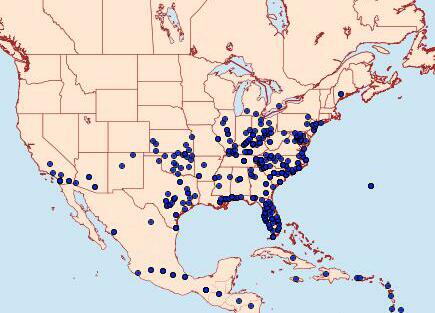
10911 - Anicla infecta Larger Map and Month Chart
Collectors and photographers can substantially improve mapping coverage by submitting lists of species they have encountered. Please use a separate list for each county (or in Canada, each location) for which you have data. Please send your lists to MPG Mapping Data. If you do not have Excel or some other spreadsheet application, a simple list can be provided in which the three data fields are separated by commas:
0021.00,Sthenopis thule,Jul
Using an Excel file, a report might look like this:
Report From: Bob Patterson
Location: 12601 Buckingham Drive, Bowie
County: Prince George's
State/Prov.: Maryland
Lati-Long: 38.969915,-76.732801
|
| 0021.00 | Sthenopis thule | Jul |
| 0269.00 | Nemapogon multistriatella | Aug |
| 0639.00 | Caloptilia stigmatella | Apr |
| 0639.00 | Caloptilia stigmatella | Aug |
| 0922.00 | Depressaria pastinacella | Aug |
| 0922.00 | Depressaria pastinacella | May |
| 2278.00 | Dichomeris glenni | Jul |
| 2301.20 | Dichomeris isa | Jun |
| 2301.20 | Dichomeris isa | Aug |
| 2492.10 | Acrolepiopsis assectella | Apr |
| 2492.10 | Acrolepiopsis assectella | May |
| 3334.00 | Catastega aceriella | Jun |
or.......
| 0021.00 | Sthenopis thule | Jul | | |
| 0269.00 | Nemapogon multistriatella | Aug | | |
| 0639.00 | Caloptilia stigmatella | Apr | Aug | Oct |
| 0922.00 | Depressaria pastinacella | May | Sep | |
| 2278.00 | Dichomeris glenni | Jul | | |
| 2301.20 | Dichomeris isa | Jun | Aug | |
| 2492.10 | Acrolepiopsis assectella | Apr | May | Jun |
| 3334.00 | Catastega aceriella | Jun | | |
| 9669.00 | Spodoptera ornithogalli | Aug | Sep | |
| 9679.00 | Elaphria chalcedonia | Jun | Jul | |
Please do not submit single records. We simply will be unable to handle a massive amount of email. Send your accumulated data and then supplement it with annual reports. If you are posting all of your photographs at BugGuide we will obtain the information there. We will not display personal information. Contributors will be acknowledged in a listing on this page.
To obtain accurate lati-longs, you may use this online application: Latitude and Longitude of a Point. It will pinpoint almost any address, place name, park or preserved area in the United States or Canada. Unsure about a county name? Type "Santa Ana NWR, Texas, County" into Google and you will quickly find out it is in Hidalgo County.
If records from the USA include the county name you do not have to supply lati-longs. We have a computer program that will do it. If you supply accurately spelled, currently valid, Latin names you do not need to supply Hodges numbers. We have a program that will do that, also. But it will be very helpful if you supply both the Hodges number and the Latin name.
You may download a copy of the North American Checklist and use it for correct spellings and numbers. It is an Excel table of 2.41 MB. Download
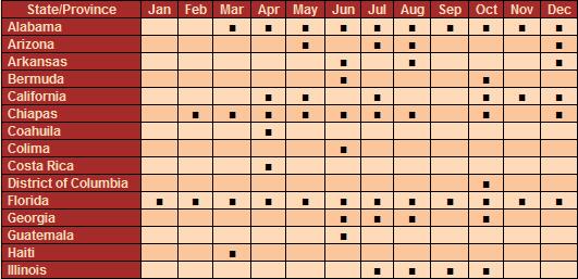
10911 - Anicla infecta (chart is truncated)
We will supply to compilers of state/provincial, regional or specialty databases records from the MPG mapping database, and request contributions from all such sources. Please keep in mind that our lati-long data are as described above, and that we store only the month and not complete dates. We do not store data pertaining to individual collectors or photographers.
We solicit the assistance of volunteers who will extract mapping information from journal articles, books, monographs and Internet documents. Use of an Excel file or other spreadsheet application may be necessary. Technical expertise is not required. If you would like to help please contact MPG.
Funding for this project was supplied by Mississippi Entomological Museum. Development of software for mapping applications and advice regarding data requirements were provided by Mike Boone. Database tables and processing of data were contributed by Bob Patterson.
|
Contributors to the MPG Mapping Project
Museum Collection Databases
- Canadian National Collection - Don Lafontaine, Chris Schmidt
- Illinois State Museum - Everett Cashatt
- Maine Forest Service - Charlene Donahue
- Mississippi Entomological Museum - Richard L. Brown
- Peabody Museum of Natural History - Larry Gall
- E. H. Strickland Entomological Museum - Felix Sperling
- United States National Museum - John Brown, Mike Pogue
- University of Guelph: BOLD Barcoding - Paul Hebert
Publications: CD, Print and Internet
Nolie Schneider, Cynthia Van Den Broek and Bob Patterson have contributed data extracted from .pdf files and other published reference material. You are invited to join in this valuable activity. Send email to MPG to volunteer.
- The Lepidopterists' Society Season Summaries - Leroy Koehn
- Wedge Entomological Research Foundation
MONA fascicle 7.6 - Gelechiidae: Ron W. Hodges
MONA fascicle 8.1 - Tortricidae: Jerry Powell & John Brown
MONA fascicle 17.2 - Geometridae: Douglas Ferguson
MONA fascicle 27.1 - Noctuidae: Don Lafontaine
MONA fascicle (forthcoming) - Acronictinae: Chris Schmidt & Gary Anweiler
- BugGuide: Iowa State University - John VanDyk
- Moths of Maine - Austin Brower
- Moths of Maryland - John Glaser
- Illinois Natural History Survey - Glenn Collection
- Lepidoptera of Florida - John Heppner
- New Brunswick & Maritimes - Tony Thomas
- Great Smoky Mountains National Park - Mike Pogue, Brian Scholtens
- Cuba - Rayner N. Aguilo, Alejandro B. Cañamero
- CBIF - Canadian Biological Information Facility - Macromoths
- Pacific Northwest Moths - Lars Crabo
State Databases
- California, Nevada, Arizona - Kelly Richers
- Moths of Iowa - Jim Durbin
- Kentucky Butterfly Net - Jeff Marcus
- Louisiana Moths - Vernon A. Brou, Jr.
- North Carolina State Parks - Tom Howard
- Ohio Lepidopterists - Rick Ruggles
- Moths of Puerto Rico - Aaron Cavosie
- South Carolina Moths - John Snyder
Collectors and Photographers
- Val Albu - Continent-wide collection
- Ken Bliss - NJ, MX
- Richard M. Brown - Hemisphere Butterflies
- Jean Dane - ME
- Bill Dempwolf - KY, NM, OK, TX
- Tom Dimock - CA
- Julian Donahue - Symmerista
- Lance Durden - St. Catherines Island, GA
- Joe Garris - NJ
- John Glaser - WV
- Jennifer Hanson - NJ
- Betsy Higgins - MA
- Kyle Johnson - MI, MN, WI
- Steve Johnson - PA
- Deb Lievens - NH
- Stuart Marcus - TX
- Debbie Matthews - Pterophoridae
- Eric Metzler - Midwest, Southwest research collection
- Tomas Mustelin - WA, CA
- Arne Myrabo - MN
- Steve Nanz - NY, ME, PA
- Bob Nuelle, Jr. - East TX Natural History Survey
- Bob Patterson - MD, FL
- Evan Rand - Southwest
- Russell Rahn - GA, KY, TX
- Greg Raterman - KY
- David Reed - ME, MN
- Kelly Richers - Continent-wide collection
- Dave Roberts - MD
- Jeff Rouze - TX
- Michael Sabourin - Tortricidae Research Collection
- Stephanie Shank - Mostly Southwestern
- Paul Sweet - IL
- William Taft - Sesiidae Research Collection
- Nolie Schneider - ON
- Jim Taylor - GA
- Martin Turgeon - NB, QB
- Jim Vargo - IN
- Dennis Washburn - VA
- Karl Wilson - NY
- Carol Wolf - FL, MI
- Robert Zimlich - AL